
FTC Disclosure: If you make a purchase via a link on this site, I may receive a small commission on the transaction - at no added cost to you. Thank you!
Cape Cod Tide Chart
"Must-Have" Printable Tide Tables
Cape Cod Tide Chart
(Sample)
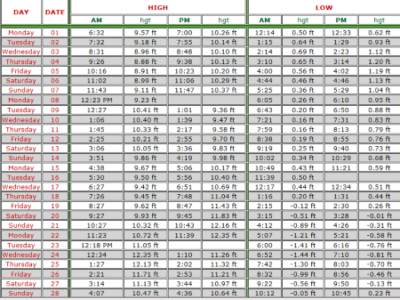
Where to Find Cape Cod Tide Tables
The best online resource I've found for accurate, daily tide tables is, without doubt, the Massachusetts Marine Trades Association.
The MMTA's charts are easy to read and print out well, too.
I make a few copies for each month. Then I stick one on our fridge, and the rest go in our beach, boating, and shellfishing bags. That way, we always have one handy whether we're on land or on the water.
Who Needs a Tide Chart?
If it's your first time visiting Cape Cod, you might be surprised to learn just how handy a daily tide chart will be ...
Beachgoers
We have some pretty amazing tides here, especially on Cape Cod Bay. When the tide goes out on the Bay side, it really goes out!
|
Water disappears quickly, leaving miles and miles of sandflats and tide pools. The water also returns quickly ... more quickly that you might imagine. Unfortunately, every couple years we hear of someone who walked out too far on the flats and couldn't make it back to dry land quickly enough when the tide started to come in. |
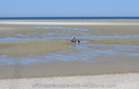 |
Before you walk out on the flats, it's critical that you know when the tides will turn to incoming, and that you get yourself back to shore well before that time!
[FYI: The water level changes are not quite as dramatic on the Ocean or the Sounds. But the same care should be taken on those beaches, too.]
Clammers
A daily tide table is one of the most important tools to have with you when you venture out to dig your own clams for dinner.
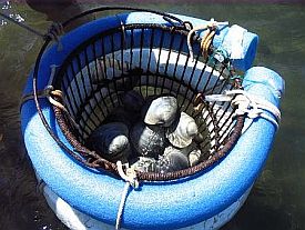 |
As avid clammers know, it's easiest to dig the tasty little morsels from the sand when the tide is low. That's when the water is most shallow and the "clam flats" are exposed.
Get to your favorite shellfishing spot an hour or two before low tide, and you'll have happy clamming ahead. |
Go too early or too late, and your digging will be much, much more challenging than it needs to be.
FYI: If you check the tide tables, you'll see that on some days there's no low tide during daylight hours. That's a good thing to know before you spend you hard-earned dollars for a clamming permit that you won't be able to use!
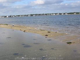
Boaters
I've always thought this was pretty basic physics. But every summer, without fail, we see one or two boaters who had to learn the hard way that ...
- Boats can't float on sand.
- Rocks hide.
- Trucks sink.
Of course, it's no secret that boats can't float on sand.
That's why I'm mind-boggled when people run their boat aground on a sandbar, and then they say: "Where did that come from? It wasn't there an hour ago."
|
Actually, the sand bar was there an hour ago. Just deeper. |
 |
Which brings me to #2: Rocks Hide.
Same principle as #1, just in reverse.
We have some very sneaky rocks around here. Particularly in the semi-shallow waters of Nantucket Sound and Cape Cod Bay.
They love to poke their pointly heads out of the water at low tide.
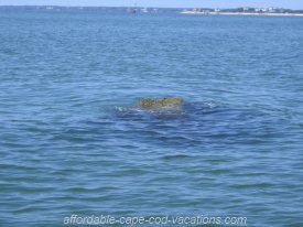 |
Then, as the tide comes in, they go into hiding. Usually they hide just deep enough that you can't see them, but shallow enough that your boat can smack them. Oops! Time to pay that nice tow boat captain again. And the boat repair man, too. |
And last but not least: Trucks Sink!
This universal truth is especially important to remember if you plan to use a boat ramp on any Cape Cod tidal waters.
Our boat ramps can be kind of funky, to say the least.
|
The ramp we use most often has a gentle slope to it. So we can launch and retrieve our boat just fine from low to about half-tide. If it's more than half-high, forget it. Other local boat ramps are good from high to about half-tide. If it's any lower than half, forget it. |
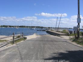 |
Oh ... and some of those "high tide ramps" have big drop-offs at the end. If you try to launch when the tide's too low, you might find out what I mean by "trucks sink".
Serious, expensive oops! Time to pay for a new vehicle.
Shoulda checked that Cape Cod tide chart!
Related Pages:
Comprehensive Guide to Cape Cod Beaches
Ask a Question About Tide Charts or Another Topic
** Don't miss This Month's Most Popular Pages at the top of this page!
Search This Site
FTC Disclosure: If you make a purchase via a link on this site, I may receive a small commission on the transaction - at no added cost to you. Thank you!
Recent Articles
-
Cape Cod Events Calendar: Fun Things to Do in June 2025
Looking for summer fun on Cape Cod? The June 2025 events calendar has all the details on this month's most popular festivals, fairs, special events, and ... -
Cape Cod Lighthouses: Where to Tour, Climb & Stay in 2025
Hoping to visit some Cape Cod lighthouses this year? Here’s where you can tour inside, climb to the top, and even stay overnight—plus tour dates, tips, and more. -
Cape Cod Mini Golf Guide: Find the Right Course for Your Game
This Cape Cod mini golf guide helps you quickly pick the best course for family outings, date nights, or just putting around with your pals.

Cape Days: Your Go To Cape Cod Guide SM
Copyright 2008-2025 - Doné R. ("Dee") Young
CapeDays.com
All rights reserved.
* As an Amazon Affiliate I earn from qualifying purchases. *
Privacy Policy | Terms of Use | FTC Disclosure | About | Contact | Site Map | Legal
Member of Yarmouth MA Chamber of Commerce
